Solis Announces: Extensive Copper Mineralisation Observed at Ilo Este
Solis Minerals (SLMFF) has announced significant copper mineralization findings from its first drill hole at the Ilo Este project in Peru. The diamond drill hole IE-001-2025, completed to a depth of 482.10 meters, revealed four distinct mineralized zones totaling approximately 350 meters from surface with copper and molybdenum present.
The drill hole intersected multiple intrusive rock sequences with significant alteration and mineralization. Visual analysis showed copper grades estimated between 0.1-0.5% Cu across different zones. A second drill hole has commenced 200 meters south southwest of the first drill pad, targeting the northern magnetic anomaly as part of a planned 5,000-meter diamond drill program.
Laboratory assays from ALS Global are expected in September 2025, which will confirm the extent and grade of mineralization.
Solis Minerals (SLMFF) ha annunciato significative mineralizzazioni di rame dal primo foro di sondaggio al progetto Ilo Este in Perù. Il foro diamantato IE-001-2025, completato fino a 482,10 metri, ha evidenziato quattro zone mineralizzate distinte per un totale di circa 350 metri dalla superficie con presenza di rame e molibdeno.
Il foro ha attraversato più successioni di rocce intrusive con marcata alterazione e mineralizzazione. L’analisi visiva ha stimato tenori di rame compresi tra 0,1-0,5% Cu in diverse zone. Un secondo foro è iniziato a 200 metri a sud-sudovest del primo piazzale, mirando all’anomalia magnetica settentrionale nell’ambito di un programma diamantato da 5.000 metri.
Le analisi di laboratorio presso ALS Global sono previste per settembre 2025 per confermare estensione e tenore della mineralizzazione.
Solis Minerals (SLMFF) ha anunciado hallazgos significativos de mineralización de cobre en su primer sondeo en el proyecto Ilo Este en Perú. El sondaje diamantado IE-001-2025, completado hasta 482,10 metros, mostró cuatro zonas mineralizadas distintas que suman aproximadamente 350 metros desde la superficie con presencia de cobre y molibdeno.
El pozo atravesó múltiples secuencias de rocas intrusivas con alteración y mineralización importantes. El análisis visual estimó leyes de cobre entre 0,1-0,5% Cu en diferentes zonas. Un segundo sondeo se ha iniciado 200 metros al SSO de la primera plataforma, apuntando a la anomalía magnética norte como parte de un programa diamantado de 5.000 metros.
Se esperan los ensayos de laboratorio en ALS Global para septiembre de 2025, que confirmarán la extensión y la ley de la mineralización.
Solis Minerals (SLMFF)��� 페루 Ilo Este 프로젝트�� �� 시추공에�� 유의미한 구리 광상 발견�� 발표했습니다. 다이아몬�� 시추�� IE-001-2025��� 482.10미터까지 완료되었으며, 지표에�� �� 350미터�� 이르��� �� 개의 구분�� 광화대에서 구리와 몰리브덴�� 확인되었습니��.
해당 시추공은 유의�� 변질과 광화가 동반�� 다수�� 관입암 계열�� 관통했습니��. 육안 분석 결과 �� 구간에서 0.1��0.5% Cu 범위�� 구리 함량�� 추정되었습니��. �� 번째 시추공은 �� 번째 패드에서 남남서로 200미터 떨어�� 지점에�� 시작되었으며, 북쪽 자기 이상�� 목표�� 하�� �� 5,000미터 다이아몬�� 시추 프로그램�� 일부입니��.
광화�� 범위와 품위�� 확인하기 위한 ALS Global�� 실험�� 분석 결과��� 2025�� 9���� 나올 예정입니��.
Solis Minerals (SLMFF) a annoncé des découvertes significatives de minéralisation en cuivre lors du premier trou de forage du projet Ilo Este au Pérou. Le trou diamanté IE-001-2025, réalisé jusqu'à 482,10 mètres, a révélé quatre zones minéralisées distinctes totalisant environ 350 mètres depuis la surface, avec présence de cuivre et de molybdène.
Le forage a intersecté plusieurs séquences de roches intrusives présentant une altération et une minéralisation importantes. L'analyse visuelle a estimé des teneurs en cuivre comprises entre 0,1��0,5% Cu selon les zones. Un deuxième trou a été entamé à 200 mètres au SSO du premier emplacement, ciblant l'anomalie magnétique nord dans le cadre d'un programme diamanté de 5 000 mètres.
Les analyses en laboratoire par ALS Global sont attendues en septembre 2025 pour confirmer l'étendue et la teneur de la minéralisation.
Solis Minerals (SLMFF) hat bedeutende Kupfermineralisierungen aus dem ersten Bohrloch des Ilo Este-Projekts in Peru bekannt gegeben. Das Diamantbohrloch IE-001-2025 wurde bis zu einer Tiefe von 482,10 Metern niedergebracht und ergab vier getrennte mineralisierte Zonen von insgesamt rund 350 Metern ab Oberfläche mit Vorkommen von Kupfer und Molybdän.
Das Bohrloch schnitt mehrere intrusive Gesteinssequenzen mit ausgeprägter Alteration und Mineralisierung. Die visuelle Analyse ergab geschätzte Kupfergehalte zwischen 0,1��0,5% Cu in verschiedenen Zonen. Ein zweites Bohrloch wurde 200 Meter süd-südwestlich der ersten Bohrplattform begonnen und zielt auf die nördliche magnetische Anomalie als Teil eines geplanten 5.000-Meter-Diamantbohrprogramms.
Laboranalysen durch ALS Global werden für September 2025 erwartet, um Umfang und Gehalt der Mineralisierung zu bestätigen.
- Visual confirmation of extensive copper mineralization across 350 meters from surface
- Multiple mineralized zones identified with estimated grades of 0.1-0.5% Cu
- Successful intersection of porphyry-style mineralization in line with exploration targets
- 100% ownership of the Ilo Este project
- Actual grades and mineralization extent pending laboratory confirmation
- Results are based on visual estimates only, which cannot substitute for laboratory analyses
HIGHLIGHTS
- The first drill hole at Ilo Este has intersected copper mineralisation in a porphyry setting.
- Visual analysis has confirmed four mineralised intersections totalling approximately 350 metres from surface with copper and molybdenum observed1. Extent of mineralisation and grade to be confirmed by laboratory assays with results expected in September 2025.
- The diamond drill hole was completed at a depth of 482.10 metres. A second drill hole has commenced in the northern magnetic anomaly, approximately 200 metres south southwest of the first drill pad.
- The objective of the current 5,000 metre diamond drill program is to explore for high-grade areas of an extensive copper-gold porphyry system2. These are being targeted across magnetic and induced polarisation ("IP") anomalies.
- Laboratory assays for Ilo Este are expected from ALS Global in September 2025. Ilo Este assays have been prioritised ahead of Chancho al Palo assays.
West Leederville, Western Australia--(Newsfile Corp. - August 26, 2025) - Solis Minerals Limited (ASX: SLM) ("Solis Minerals" or "the Company") is pleased to announce an update on its 100 per cent owned Ilo Este project in southern Peru.
Ilo Este has been previously explored between 2000 - 2001 and 2014 - 2016 (Figure 4). Historical drilling identified significant mineralisation consistent with a large copper-gold porphyry system. Recent geochemical and geophysical studies completed by Solis Minerals have identified new areas within northern and southern magnetic anomalies which are thought to contain higher grade copper- gold mineralisation. The current 5,000 metre drilling program will drill these magnetic and previously undrilled IP targets.
Chief Executive Officer, Mitch Thomas, commented:
"We're very excited by evidence of significant mineralisation at Ilo Este. First assays are expected in September 2025. We have encountered mineralisation across long intercepts of approximately 350 metres.
While assays will determine grades and overall prospectivity, we are very encouraged by the geology, alteration, and visual results."
1 Visual estimates of mineral abundance should never be considered a proxy or substitute for laboratory analyses where concentrations or grades are the factor of principal economic interest. Visual estimates also potentially provide no information regarding impurities or deleterious physical properties relevant to valuations. Laboratory assays are expected in September 2025.
2 Refer to SLM:ASX announcement 11 August 2025:
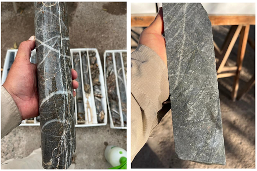
Figure 1 (left image): IE-001-2025 drill core from 177 to 180 metres showing potassic alteration and stockwork. Visually estimated grade 0.1 -
Figure 2 (right image): IE-001-2025 drill core from 320 to 321 metres displaying granular microdiorite. Visually estimated grade 0.1 -
To view an enhanced version of this graphic, please visit:
https://images.newsfilecorp.com/files/1134/263950_solis_figure1and2.png
Diamond drill hole IE-001-2025 was completed to a depth of 482.10 metres. The hole intersected a sequence of intrusive rocks, namely granular microdiorites and porphyritic quartz diorites, with multiple fault zones and breccias, and significant alteration and mineralisation. Granular microdiorites predominated (Figure 2) except for a porphyritic quartz diorite unit from 51.3 to 192.25 metres. Granodiorite of the Coastal Batholith was encountered at 461.5 metres - the footwall unit to mineralisation. Of particular interest was an altered and partially mineralised stockwork from 177.5 to 266.3 metres showing three to five generations of quartz veining (Figure 1).
Visual mineralisation was observed in four distinct zones:
a) From surface to 51.3 metres predominantly Cu oxides in joints and fractures.
b) From 51.3 to 103.3 metres a mixed zone of Cu oxides in fractures and some disseminated chalcopyrite.
c) From 176.7 to 221.6 metres a stockwork with some disseminated and minor vein-hosted chalcopyrite.
d) From 266.3 to 406.3 metres some chalcopyrite with associated molybdenite in A and B veins, and disseminations. Continuing to 471.3 metres as disseminations (Figure 3).
Alteration generally increased downhole with moderate secondary biotite and quartz veining from surface to 177.5 metres, followed by moderate to intense potassic alteration (secondary biotite with quartz veining) in a stockwork to 265.4 metres, followed by intense potassic alteration to 461.5 metres - with A and B veins carrying the best mineralisation observed from 266.3 to 406.3 metres. Disseminated magnetite was observed from 383.0 to 424.20 metres, supporting the Northern Magnetic Anomaly footprint (Figure 4). A summary of the geology, alteration, and visual mineralisation estimates is shown in Table 1.
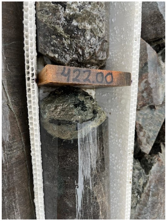
Figure 3: IE-001-2025 drill core at 422 metres displaying sulphides in quartz veining in granular diorite. Visually estimated grade 0.1 -
To view an enhanced version of this graphic, please visit:
https://images.newsfilecorp.com/files/1134/263950_solis_figure3_550.jpg
The second drill hole at Ilo Este, located approximately 200 metres south southwest of the first, will similarly target a northern magnetic anomaly (Figure 4). The total programme at Ilo Este is planned for approximately 5,000 metres or approximately ten diamond drill holes.
Ilo Este
The drilling program at Ilo Este is designed to test priority geophysical and geochemical anomalies interpreted to represent porphyry-style mineralization systems3. Key objectives of the planned 5,000 metre campaign include:
- Target validation: confirm geological and structural interpretation of induced polarisation and magnetic anomalies that vector targeting for potential porphyry-style copper systems.
- Mineralisation confirmation: intersect and characterise primary copper mineralisation, with associated alteration halos (e.g., sodic-calcic, potassic), sulphide zoning, and potential pathfinder elements (Fe, Au, Mo, REEs) within targeted lithological and structural settings.
- Alteration system mapping: delineate the extent and geometry of hydrothermal alteration systems, to vector toward the core of mineralised zones and assess potential fluid pathways.
- Structural controls: evaluate the role of faulting, brecciation, and intrusive contacts in localizing mineralization, particularly within interpreted feeder zones or structural corridors.
- Resource potential assessment: collect sufficient geological, mineralogical, and geochemical data to guide future step-out drilling and preliminary evaluation of the project's resource potential.
3 Refer to SLM:ASX announcement 29 April 2024:
Description of Drillhole IE-001-2025
| Start date: | 7 August 2025 |
| End date: | 18 August 2025 |
| Survey | |
| Platform: | P-15, drill hole reference IE-001-2025 (Figure 4) |
| Azimuth: | 325 |
| Dip: | -50 |
| Depth: | 482.10 (EOH) |
| Collar | |
| East UTM 19S: | 270656 |
| North UTM 19S: | 8057763 |
| Elevation (m): | 922 |
| Datum: | WGS84 |
Visual estimates of mineral abundance should never be considered a proxy or substitute for laboratory analyses where concentrations or grades are the factor of principal economic interest. Visual estimates also potentially provide no information regarding impurities or deleterious physical properties relevant to valuations. Laboratory assay results are expected in September 2025.
The hole was collared to drill into magnetic anomaly with favourable surface geological indicators and historical drilling completed4.
4 Refer to SLM:ASX announcement 11 August 2025:
The hole traversed several units detailed below
| Hole depth (metres): | Geology, Alteration, Mineralisation | Visual grade estimate (%) |
| 0.00 - 0.80 | Overburden (soil) | - |
| 0.80 - 28.00 | Microdiorite with moderate potassic alteration, weak quartz veinlets, traces of copper oxides | 0.1 - |
| 28.00 - 28.90 | Fault zone with intense oxidation | 0.1 - |
| 28.90 - 51.30 | Microdiorite with moderate potassic alteration, quartz veinlets, hematite-calcite in fractures, traces of copper oxides. | 0.1 - |
| 51.30 - 103.30 | Porphyritic quartz diorite with quartz-CuOx veinlets, some disseminated copper sulphides; fault gouge zones. Mixed zone. | 0.1 - |
| 103.30 - 192.25 | Predominantly porphyritic quartz diorite, moderate potassic alteration, quartz veinlets, pyrite. Some disseminated copper sulphides from 176.70 to 192.25 metres in stockwork. | 0.1 - (176.70 - 192.25 m) |
| 192.25 - 266.30 | Microdiorite and lesser porphyry quartz diorite with stockwork quartz veinlets - some with chalcopyrite, pyrite up to 221.6m hole depth. Moderate to intense potassic alteration. | 0.1 - (192.25 - 221.60 m) |
| 266.30 - 406.30 | Microdiorite with intense potassic alteration, A and B veins, moderate copper sulphides some associated with molybdenite. Magnetite from 383m. | 0.1 - |
| 406.30 - 461.50 | Microdiorite, intense potassic alteration, moderate copper sulphides, magnetite to 424.2m. | 0.1 - |
| 461.50 - 482.10 | Granodiorite - Coastal Batholith | < |
Table 1: Summary description of geology, alteration and visual mineralisation estimates encountered in drill hole IE-001-2025. Laboratory assay results are expected in September 2025. Visual estimates of mineral abundance should never be considered a proxy or substitute for laboratory analyses where concentrations or grades are the factor of principal economic interest. Visual estimates also potentially provide no information regarding impurities or deleterious physical properties relevant to valuations.
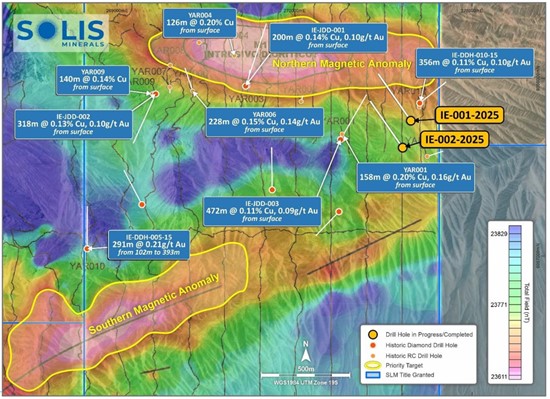
Figure 4: Ilo Este drill targets across northern and southern magnetic anomalies; first and second drill hole locations depicted, IE-001-2025 (completed) and IE-002-2025 (underway). Location, sequence and number of subsequent drill holes to be determined subject to programme results. Refer to ASX: SLM announcement of 11 August 2025 for more information on historical drillhole results.
To view an enhanced version of this graphic, please visit:
https://images.newsfilecorp.com/files/1134/263950_solis_figure4_550.jpg
ENDS
This announcement is authorised for release by the Board.
Contact
Mitch Thomas
Chief Executive Officer
Solis Minerals Limited
[email protected]
+61 458 890 355
Media & Broker Enquiries:
Fiona Marshall
White Noise Communications
[email protected]
+61 400 512 109
About Solis Minerals Limited
Solis Minerals is an emerging exploration company, focused on unlocking the potential of its South American copper portfolio. The Company is building a significant copper portfolio around its core tenements of Ilo Este and Ilo Norte and elsewhere in the Coastal Belt of Peru.
The Company is led by a highly-credentialled and proven team with excellent experience across the mining lifecycle in South America. Solis is actively considering a range of copper opportunities. South America is a key player in the global export market for copper and Solis, under its leadership team, is strategically positioned to capitalise on growth opportunities within this mineral-rich region.
Forward-Looking Statements
This news release contains certain forward-looking statements that relate to future events or performance and reflect management's current expectations and assumptions. Such forward-looking statements reflect management's current beliefs and are based on assumptions made and information currently available to the Company. Readers are cautioned that these forward-looking statements are neither promises nor guarantees and are subject to risks and uncertainties that may cause future results to differ materially from those expected, including, but not limited to, market conditions, availability of financing, actual results of the Company's exploration and other activities, environmental risks, future metal prices, operating risks, accidents, labour issues, delays in obtaining governmental approvals and permits, and other risks in the mining industry. All the forward-looking statements made in this news release are qualified by these cautionary statements and those in our continuous disclosure filings available on SEDAR+ at These forward-looking statements are made as of the date hereof, and the Company does not assume any obligation to update or revise them to reflect new events or circumstances save as required by applicable law.
Qualified Person Statement
The technical information in this news release was reviewed by Michael Parker, a Fellow of the Australian institute of Mining and Metallurgy (AusIMM), a qualified person as defined by National Instrument 43-101 (NI 43-101). Michael Parker is Technical Director of the Company.
Competent Person Statement
The information in this ASX release concerning Geological Information and Exploration Results is based on and fairly represents information compiled by Mr Michael Parker, a Competent Person who is a Fellow of the Australasian Institute of Mining and Metallurgy. Mr Parker is Technical Director of Solis Minerals Ltd. and has sufficient experience which is relevant to the style of mineralisation and types of deposit under consideration and to the exploration activities undertaken to qualify as a Competent Person as defined in the 2012 Edition of the "Australian Code for Reporting of Mineral Resources and Ore Reserves". Mr Parker consents to the inclusion in this report of the matters based on information in the form and context in which it appears. Mr Parker has provided his prior written consent regarding the form and context in which the Geological Information and Exploration Results and supporting information are presented in this Announcement.
APPENDIX 1
JORC Code, 2012 Edition - Table 1
| Criteria | JORC Code explanation | Commentary |
| Sampling techniques |
|
|
| Drilling techniques |
|
|
| Drill sample recovery |
|
|
| Logging |
|
|
| Criteria | JORC Code explanation | Commentary |
| Sub-sampling techniques and sample preparation |
|
|
| Quality of assay data and laboratory tests |
| All rock chips will be assayed by ALS in Lima. Methods intended to use:
|
| Verification of Sampling and assaying |
|
|
| Location of data points |
|
|
| Data spacing and distribution |
|
|
| Criteria | JORC Code explanation | Commentary |
| Orientation of data in relation to geological structure |
|
|
| Sample security |
|
|
| Audits or reviews |
|
|
Section 2 Reporting of Exploration Results
(Criteria listed in the preceding section also apply to this section)
| Criteria | JORC Code explanation | Commentary |
| Mineral tenement and land tenure status |
|
|
| Exploration done by other parties |
|
|
| Geology |
|
|
| Drill hole Information |
|
|
| Criteria | JORC Code explanation | Commentary |
| Data aggregation methods |
|
|
| Relationship between mineralisation widths and intercept lengths |
|
|
| Diagrams |
|
|
| Balanced reporting |
|
|
| Other substantive exploration data |
|
|
| Further work |
|
|
![]()
To view the source version of this press release, please visit